CONUS Map with Navigable Major Rivers
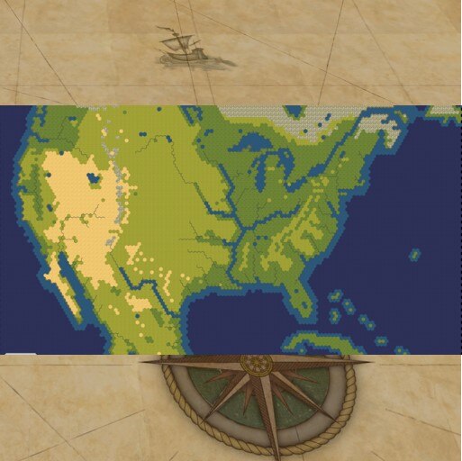
Map of southern Canada, northern Mexico, and all of the continental United States. Major Rivers (e.g., Mississippi, Missouri, Rio Grande, Columbia, Ohio, St. Lawrence Seaway) are navigable by being single tile coastal water tiles. The map attempts to not only attain geographic realism of central, pre-Columbian North America but also the approximate placement of the various resources of the continent as well.
Map size is ENORMOUS (128×80) with reliance on YnAMP.
The November 2020 update now adds three bonus maps:
- CONUS – West, a 60×80 map of the western section of the primary CONUS map. TSLs included.
- CONUS – East, an 80×80 map of the eastern section of the primary CONUS map. TSLs included.
- CONUS – Eastern with Colonizer Starts, a 96×80 map of the eastern section of the primary CONUS map plus four artificial, legendary start islands along the eastern border with start locations for England, the Netherlands, France, and Spain and no TSLs for the real lands, which allows for some colonization-style competition.
Works with vanilla, R&F, & GS.
Key Features / Recent Updates:
- Start Locations are available via Advanced Settings (i.e., set ‘Civilization Placement’ to ‘True Start Locations’).
- Major Rivers provide fresh water.
- Real City Names are provided (3,193 unique city names included).
- Embarkation of workers and scouts available ab initio via complementary second mod).
Recommended complementary mods:
Special Thanks to:
- Gedemon for YnAMP, to whom thousands of us are indebted.
- TheCzolgosz for some helpful explanations in his XMLs regarding Real-City Naming.
- Junky for working out how to mod embarkation at start and inspiring one of my other mods: EmbarkAbInitio.
A few configuration tips:
- Coastal Flooding: I have not figured out how to set elevations on the tiles bordering the "major rivers" so that rising sea levels don’t inundate the upper Mississippi or the Great Lakes during rising sea levels. To prevent the flooding in full on GS games, when configuring advanced settings set the ‘Coastal Low Land’ to ‘Import’ rather than ‘Map Generator.’
- TSL is ON by default. You MUST, however, also select Allow random placement for civs without TSL or the game will glitch out and not load non-TSL civs.
- ‘Enforce TSL’ mandates that intial settlers build the first city immediately. It is defaulted to OFF, so you can move away from your initial start.
- ‘Real City Naming’ is ON by default.
I’ve started work on a Great Lakes map with similar approach.

