Border Crossing: El Paso
Welcome to The Sun City region of El Paso, Texas. El Paso (Elevation 3740ft) stands on the Rio Grande across the Mexico–United States border from Ciudad Juárez, the most populous city in the Mexican state of Chihuahua. In the year 2019 the United States exported over 300 Billion USD in imports from Mexico and exported over 200 Billion USD of products to Mexico.
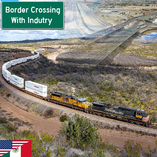
Despite political, sociological, crime, and other tensions the trade relationship between these two border countries continues to thrive. El Paso is considered one of the largest gateway cities of trade between the two countries. El Paso presents unique challenges in limited space, terrain, the border itself as an obstacle, and import/export rail choke point that exist in real life.
- Highly detailed real-world topography (1/3 arc second detail)
- Rich agriculture networks in the river valley
- Mainline Connection Game Play™
- Real world freight types and directional demands (both internally inside the US and imports/exports with Mexico)
- Real world placement and naming of local industries and roads
- Rail logistics choke point at the border’s rail crossing. Can you solve this real world problem and keep up with demands?
- Serve the region’s local industries and subdivisions via imported region freight and ship finished products down line
- Conquer terrain and engineering challenges
This is a new style of map game play I have developed that primarily focuses on the transportation of items from Point A to Point B vs. the standard TF logistics of connecting and completing all of the building steps and processes. Locations on each side of the line’s exit of the map are called "Portals". Portals reflect real world freight types and proportional good demand in their various directions of travel.
Map cargo demands can be found here: https://docs.google.com/spreadsheets/d/1kMGPgnYGjQdo65k7MNmbbA8uLhuwItchVzlErzcAlg4/edit?usp=sharing
To use the portals, simply connect a freight station to the road that runs through them. All generated goods will be sent straight to the depot! Remember that industries will not begin producing goods until there is a destination demand and an appropriate form of transportation (tankers for fuel, box trucks for goods, etc.) to that destination.
- Border Crossing – You will need to build over the border fence or delete a slot to build through it
- Crossing Options – Only the main road bridge border crossing exist, however, there is additional crossings (The region’s only other real world crossing locations) east and west of El Paso that can be connected.
- Starting date – You can change the starting year by playing in sandbox mode to access today’s machines and rolling stock
- Highway Network – Interstate 10 crosses the full map. I have fenced I-10 off near cities to prevent the highway being taken over by city growth. All portals are near road connections including I-10 so feel free to use road based transportation if inclined.
- Realistic Track Placement – I recommend pausing the game early to lay track and yards near the border in the cities which is where they exist in real life. Use Google Earth to help with exact track placement.
It was tough to find drive to finish this map during the summer with so many other distractions, but I’m glad it’s finally done. This map has over 90 hours developing, building, terrain forming, and hand painting textures, and placing vegetation/rocks. I used Texas and US Government trade rail studies and reports to figure out what goods come into the region, what directions they travel, and how much of it (link provided below).
I used to fly in/out of the El Paso area for my old job often and I feel like I’m back in West Texas every time I load up this map. The rail crossing at the border plus the close proximity to cities and terrain will make this map challenging to efficiently move freight around all parts of the map with the mountain range blocking the north. I hope you will take time to share your solutions in the comments below with all of us! Move that metal and make money!
Subscribing and rating my map is my pay!
http://ftp:/ftp.dot.state.tx.us/pub/txdot-info/rail/freight/el_paso.pdf/
Required items:
Click the title to search on this site.
Fences — Steam Workshop
Rocky Climate — Steam Workshop
Freestyle Industries — Steam Workshop

